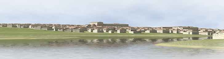
The city spread out across the Sainte-Geneviève hill, seen from the Ile Saint-Louis.
3D graphics © A.-B. Pimpaud.
The city on the left bank was built on the top and sides of the Sainte-Geneviève hill, away from damp areas subject to flooding, as was the practice in Roman Gaul. Originally, the majority of this sector was given over to housing, which was built on land that sloped down to the river Bièvre and to the Seine. This provided good drainage for both waste water and rainwater.
Distinct from the rest of the hill, the northern slope contained not only houses, but also all of the city's monuments. The builders used the sloping ground to seat the public monuments on several levels. This is the case of the forum, the theatre and the Cluny baths. As the amphitheatre, the builders chose to construct it against the backside of the hill, outside of town.
Even more than the practical and technical reasons for building on a hill, we can see in these arrangements a desire to "present" the city via its largest and most Roman assets. Seen from the Seine, we can imagine the urban landscape of a monumental Roman town rising in stages up the Sainte-Geneviève hill, the pride of its leading citizens who thus were able to show their allegiance to the Empire. At the top was the forum and its baths, further down was the theatre, the Collège de France baths and the amphitheatre, and finally, at the bottom, the Cluny baths-all of them together forming a monumental vista. The modest residential district of the Saint-Séverin hillock was intended to not block the view of the town's "face".