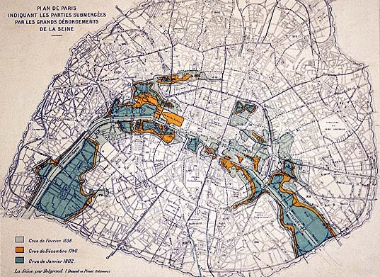
Map of the great floods of the Seine in modern times, drawn up in 1872 by Belgrand. The famous flood of 1910 followed the same course. This map suggests how Paris may have looked prior to urbanisation. In particular, the fossil trace of the river's northern branch can be seen.
© Commission du Vieux Paris.
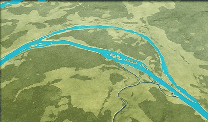
Location of the Seine
Infographic © A.-B. Pimpaud
We should not imagine that the Seine in Antiquity looked like its current, highly channelled state. The map of the great floods of the past shows the original complexity of the river and its tributaries that formed a network of several successive channels.
The principal riverbed
Since the mid-Neolithic, the path of the main riverbed was probably the one we know today. We have established that it flowed more to the north at the level of Bercy and more to the south near Grenelle, accenting the gentle curve that we can observe today.
Secondary beds
The paths of the secondary riverbeds have completely disappeared under urbanisation, even if their topography can still be faintly detected.
This is particularly true of the branch that was covered over by the Boulevard Saint-Germain - we know that it was active during the Gallo-Roman period.
On the right bank, the northern branch is still perceptible today, as we can see from the trace of the great flood of 1910: the path of the ancient branch roughly corresponds to the big right-bank boulevards. Its size leads one to think that, for a time, it was the river's principal pathway.
The Banks
In contrast to today's built-up, cemented borders, we must picture the banks of the Seine combined with floodable grasslands and marshy areas, as is the case at the mouth of the Bièvre, or between the Seine and the slopes of the Sainte-Geneviève hill. The first quays only appeared with urbanisation activities.
Le tracé des lits secondaires a complètement disparu avec l’urbanisation, même si leur topographie est encore légèrement sensible. C’est le cas en particulier du bras recouvert par le boulevard Saint-Germain et dont on sait qu’il était actif pendant la période gallo-romaine.
Sur la rive droite, le bras nord est encore perceptible à l’époque moderne, comme l’atteste le relevé de l’inondation de 1910, son tracé fossile correspondant approximativement aux grands boulevards de la rive droite. Son importance laisse penser qu’il a pu, à un moment, être le lit principal du fleuve.