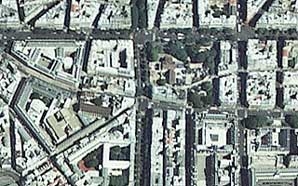
Current street plan.
Photo © IGN Photothèque Nationale - 1999
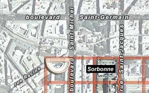
A reconstruction of the theatre superimposed on the current street plan.
Infographie © M.-O. Agnes et A.-B. Pimpaud.
Cliché © IGN Photothèque Nationale - 1999
The monument fit perfectly into the basic Roman grid pattern. If we include the adjoining road system in the calculation, the theatre fits in a space that is 300 Roman feet. square. To the north, it was bordered by the decumanus of the Rue des Ecoles, and to the east by the cardo maximus of the Boulevard Saint Michel, which was 30 Roman feet wide at that point. To the west, it was probably bordered by another road of similar size, while the side with the semicircular seating was also bordered by a road that was very likely a public square.
As was customary, the builders used the slope of the Saint-Geneviève hill to support the theatre's cavea.
Even though the building has been only partially excavated, it is possible to propose a reconstruction. Its dimensions and proportions are based on the town's urban grid. The foundation's theoretical zero point was the center of the semicircle, i.e. the middle of the diametral wall that formed the southern face of the pulpitum. All of the preliminary measurements-traces of which have been found-made by the surveyors were made from this point. The stage ran the length of the circle's 240-foot diameter, and it was 40 feet wide: one fourth of the radius. The theatre measured 160 feet (120 + 40) north to south and 240 feet east to west.
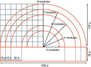
Hypothetical reconstruction of the dimensions of the building based on a unit of 15 Roman feet (1/20th of the town grid unit).
Drawing: © D. Busson et V. Charlanne.