- Home
- Megalithism in Morbihan
- Locmariaquer
- The peninsula and its monuments
- Introduction
- Carnac
- Gavrinis
-
Locmariaquer
- The peninsula and its monuments
- A cradle of archeological research
- Before the megaliths
- Grand-Menhir (Great Menhir)
- Er-Grah Tumulus
- La Table-des-Marchands (Merchants’s table)
- From Mané-Lud to Mané-er-Hroeg
- Pierres-plates (Flat Stones), a late tomb
- Megalithic art in Locmariaquer
- Locmariaquer, from Antiquity to the Middle Ages
- Le Petit-Mont
- Architectural types
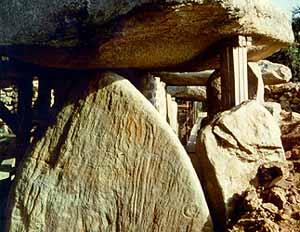
Reverse side of the Table-des-Marchands decorated capstone
This 6km long and 2 to 3km wide strip of land encloses the Morbihan Gulf to the West and forms the right bank of the deep ria of the Auray river. The altitude never exceeds 10m (with a few exceptions) and a lot of marsh land lies in its western half. The bedrock is almost exclusively Carnac granite, a highly fissured, medium grain and orientated texture rock. Therefore, only a few sites in this area were liable to produce large unfissured slabs.
Strips of migmatites with discontinuous stratification can be found in the granite to the East and South of the peninsula. They yielded some medium-sized slabs and the Kerpenhir menhir.
Two allochtonous rocks were also used by megalith builders in Locmariaquer.
- The coarse-grained orthogneiss which produced the main slabs (including some very large blocks like the Grand-Menhir for instance) cannot be from local deposits. The deposits now accessible are located to the north of Auray, to the south of Vannes (Arradon) or on the north coast of the Rhuys peninsula (Sarzeau). They are all about 10km away from Locmariaquer and separated from it by water.
- A quartzite slab forms the capstone of the Table-des-Marchands dolmen; the remains of similar Eocene superficial rocks were found in the East of the Morbihan Gulf, but always at least 10 km away from Locmariaquer.
A dozen megalithic monuments can be found today within the boundaries of the "commune", including at least seven major sites:
- the "carnacean" Mané-Lud tumulus and its related dolmen,
- Er-Grah long tumulus,
- "Grand-Menhir brisé" (Great broken Menhir),
- the Table-des-Marchands cairn with passage grave,
- the Mané-Rutual double-chambered dolmen,
- the "carnacean" Mané-er-Hroeg tumulus and its satellite menhirs,
- the Pierres-plates L-shaped tomb.
Data on the group of monuments comprising Er-Grah tumulus, Grand-Menhir and Table-des-Marchands was completely updated by excavations carried out between 1986 and 1994 by teams led by J. L'Helgouac'h and C.-T. Le Roux. This web site is based on the findings of this research, the definitive publication of which is in process.
