- Home
- Megalithism in Morbihan
- Locmariaquer
- Grand-Menhir... and the others
- Introduction
- Carnac
- Gavrinis
-
Locmariaquer
- The peninsula and its monuments
- A cradle of archeological research
- Before the megaliths
- Grand-Menhir (Great Menhir)
- Er-Grah Tumulus
- La Table-des-Marchands (Merchants’s table)
- From Mané-Lud to Mané-er-Hroeg
- Pierres-plates (Flat Stones), a late tomb
- Megalithic art in Locmariaquer
- Locmariaquer, from Antiquity to the Middle Ages
- Le Petit-Mont
- Architectural types
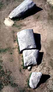
Four large blocks lying on the ground remind us of what may have been one of Mankind's greatest technical feats: extracting a 20m long monolith weighing 280 tonnes, dressing it, transporting it over a distance of 10km and erecting it around 45 centuries BC.
"No quarry in the vicinity could have provided that type of stone."
In 1778, the geographer Ogée was the first to wonder about the stone used for the huge megalithic blocks at Locmariaquer.
Geologists have now shown that it is orthogneiss. The only orthogneiss quarries (near Auray, le Bono, Arradon or Sarzeau) are at least 10km away from Locmariaquer.
However unbelievable the feat may seem, it therefore seems likely that the stone was in fact moved over such distances (a feat, moreover, repeated for other giant orthogneiss blocks found in different monuments at Locmariaquer). Given the period, there are two possible hypotheses:
- One is that the stones were entirely carried overland, a possibility recently explored by F. Bougis. This would only have been possible from the quarry located to the North of Auray. The block was either dragged (lying on a "wooden cradle", using log rollers on wooden "tracks"), or moved sideways by making it pivot around its centre of gravity. On the basis of tests carried out at Bougon (Deux-Sèvres, France) by J.-P. Mohen and later by B. Poissonnier, it can be demonstrated that more than 4000 people would have been required using the simplest techniques, but only about one hundred with more sophisticated systems, for a journey lasting more than two weeks.
- Floating must also be considered since Auray and Arradon quarries are located near channels which were already under water during the Middle Neolithic. According to C.-T. Le Roux, a large raft supported by dugouts could have been compatible with the draughts and tidal ranges at that time, over a great part of the journey. The stone could therefore have easily been transported in a few hours using tidal currents... if the crew was able to control such a huge raft!
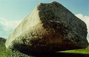
A close study of the Grand-Menhir reveals that almost the whole surface of the block has been smoothed by pecking, probably with heavy stone strikers.
An "axe-plough" figure, still visible on the middle fragment, was sculpted half-way up the block. Only the first 2.5m or so of the base was left untouched (i.e. the depth of the blocking pit).
At its bottom end, a small round surface was carefully pecked: this "hinge" was probably used to balance the stone.
The Grand-Menhir in the countryside near Locmariaquer at the beginning of the 19th century.
The aerial view highlights the difference between the main clean fracture which cuts the monolith in two and the other breakage points.
Transporting the Grand-Menhir slung under a raft supported by dugouts
The base of the lower fragment remained untouched, apart from a small "hinge".
As a giant falls, an alignment disappears
Several theories have been mooted to explain the break-up of the monolith. The breakage points visible on the three fragments aligned on the ground show large splinters (which could have resulted from a sudden fall).
However, the main breakage point is a perfectly clean fracture and might even have been caused or guided by the slight crenelations visible around its edges. Whatever the cause, there is no reliable historical testimony of Grand-Menhir still standing even, for instance, in the 15th century navigation manual describing the entrance of the Morbihan Gulf, which would probably have mentioned such a noticeable landmark.
The way the fragments are lying suggests that the monolith was in fact erected before it fell down. Several theories have recently been explored by F. Bougis. One unlikely explanation is lightning. Another plausible theory sees an earthquake as the possible cause.
Human causes have also been mentioned. The Gallo-Romans were of course suspected (the monolith is located near a major settlement), but J. L'Helgouac'h suggested that Neolithics themselves broke up the monolith, only a few centuries after it was erected.
Excavation revealed 18 stone-filled pits, decreasing in size and aligned over more than 55m in a northerly direction from the base of the Grand-Menhir. These are ancient menhir packings. Statigraphic observation dates the break-up towards the end of the 5th millennium BC. This new data questions the old theory about the Grand-Menhir being a "guiding target" for long-distance astronomical observation. It also brings into question the links between the giant monolith, the associated menhirs, and the other monuments in the vicinity.
The lower fragment under horizontal light; note its pecked surface and the crenelated edge of the fracture.
The line of packings leading northwards from the Grand-Menhir is what is left of a megalithic alignment, which was probably broken up during the Neolithic period.


