The Menec, Kermario and Kerlescan megalithic sites are not the only famous groups of menhirs in the Carnac area :
- The Petit-Menec alignments at La Trinité-Sur-Mer run on from the Kerlestan alignments. Their overall shape is curved. On their western end, they run from east to west whereas on the opposite end, they run from the north-east to the south-west. They cover almost 400m but their original width is only visible in the central part (8 lines over 50m). This group of menhirs was severely damaged, especially when the Belle-Ile lighthouse was built at the end of 19th century. As a consequence, the organisation of the megalithic monument is difficult to understand today.
- The Kerzerho alignments at Erdeven: the oldest reports - possibly exaggerated - describe lines stretching over almost 2km. At the end of the 19th century, the two ends were the only elements easily identifiable.
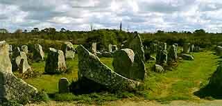
Partial view of the Kerzerho alignments (western part).
A local road (D.781) unfortunately cut through about ten lines of the alignments in 1877, at the western end, probably where the lines met the final enclosure. A little further north, a line of about fifteen stones leads outwards from a line of giant monoliths, the tallest of which reaches a height of 6m.
The eastern end is located in the Coat-er-bleis woods. It ends near the Mané-Groh passage tomb and the Lannec-er-Gadouer tumulary mound, a monument recently studied.
- The Saint-Pierre alignments are located near St. Pierre-Quiberon church. The remaining 23 menhirs of the alignments are laid out in four lines near a vast bow-shaped monument consisting of about 40 contiguous blocks and widely open to the east.
Enclosures not connected to any alignment can also be found.
- In the Morbihan Gulf (Arzon), the famous Er-Lannic horseshoe-shaped enclosure clearly shows that the sea level has risen since the Neolithic. In 1927, Le Rouzic showed that there were complex buried structures near the menhirs. Many artefacts were collected from these structures, their dating indicating that they go back to the Middle Neolithic.
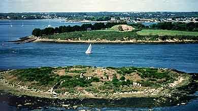
Aerial view of the upper enclosure of Er-Lannic at low tide. In the background, the Gavrinis cairn.
Other megalithic enclosures:
- at Crucuno (Plouharnel), 22 blocks are arranged in a 17x13m rectangle. Nowadays, the diagonals point towards the solstice sunrises and sunsets but a map drawn before the restorations of the 19th century shows that the original layout was not at all as regular.
- at Crucuny (Carnac), about thirty menhirs form a vast bow widely open to the east, near a funeral mound.
Small alignments are scattered throughout the Carnac landscape:
- the Sainte-Barbe and the Vieux-moulin alignments at Plouharnel,
- the Keriaval alignments, near a passage grave in the north of Carnac,
- the two Kerderff menhirs, very fine examples to the west of Le Menec, etc.
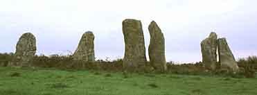
The Vieux-Moulin alignments at Plouharnel.