- Home
- Megalithism in Morbihan
- Introduction
Located at the heart of the largest megalithic area in western France, the Morbihan, and more particularly its coastal area, concentrates a large number of monuments, which are exceptional by their scale and variety. This implies the presence of a particularly dense and dynamic population, sufficiently prosperous to build such monuments.
These exceptional circumstances seemingly arose during the first half of the 5th millennium B.C. and came to an end at the beginning of the 3rd millennium B.C.. But why did such circumstances arise in the first place?
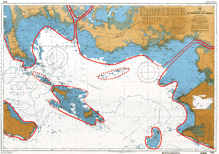
At the beginning of the 5th millemium B.C., with a sea level lower than its present level by some 7 to 8 meters, the coastline must have looked very different from the one we know today.
It is likely that the shallow waters stretching between Quiberon and the offshore islands of Houat and Hoedic covered what was then a vast area of dry land (still clearly visible on present-day sea charts).
This land must have progressively shrunk as the sea encroached further and further. However, it effectively protected an enclosed sea -the ancestor of the present Mor-bras- for many centuries.
Accessible by coastal navigation, the whole area must have constituted an ecosystem with varied resources:
- a shallow, semi-enclosed sea, particularly propitious for fishing;
- a coastal plain easy to prepare for cultivation;
- the estuaries of the Auray and Vannes rivers, as well as the Vilaine and Oust rivers, which opened up other possibilities (upstream migration of salmons, etc.) and provided ways of penetrating further into the peninsula;
- a hilly, wooded hinterland abundant with outcrops.
Hypothetical outline of the Morbihan coast during the Neolithic Period
Location of the Morbihan Megalithic Tombs
The Morbihan Megalithic Tombs
Tombs with a single chamber
Tombs with an elongated chamber
Tombs with a partitioned chamber
Gallery graves


