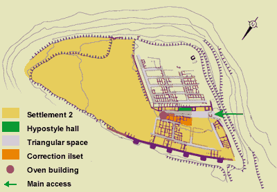
Plan of the oppidum, settlement 2
A new city wall
A few decades after the construction of the first city, a new city wall enlarged the protected space to the east and north. The total surface area of the agglomeration was increased to approximately 3.5 hectares. In order to increase defensive efficiency, the builders decided to isolate the triangular protrusion of the plateau summit where settlement 1 was located with a rectilinear fortification 400 meters long.
The mass of this fortification is very impressive. Potential assailants were blocked by a 3.5-meter wide wall of large
blocks, which must have been 6 or 7 meters high. Each 18.5 meters a massive, 9.5-meter wide tower protruded approximately 5.3 meters in front of the curtain wall. The towers could have been as high as 8 or 9 meters. We do not know the nature of the top of the towers.
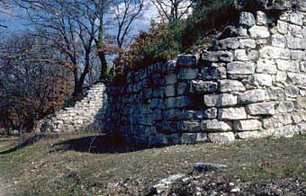

The city wall of the 2nd agglomeration
Internal organization of the agglomeration composed of islets of small houses.
The internal organization of the new city
The internal organization of the new city is still poorly known since only a small part of it has been excavated. A few characteristic traits can nonetheless be described.
The diverging orientations of the old and new fortifications, which required the construction of a row of “correcting” islets with a trapezoidal form, long prevented us from understanding the layout of the new city. We now know that it organized in square islets of 24 meters, which is equivalent to 2 islets of settlement 1 plus the street separating them.
The construction of the fortification on the slope prevented the evacuation of rainwater. It was therefore necessary to construct drainage lines to collect the water in the exterior road and direct it toward the outside, passing through the houses and fortification.
The end of access route to the new oppidum on the western slope was designed to preserve a triangular space in front of the old fortification. It is possible that this space served as a collective meeting place. Meanwhile, it is certain that it served to highlight the symbolic areas of the community, since it opened onto several collective buildings. A small building (a ritual chapel?) welcomed the visitor who next came upon an ensemble that is still poorly understood. This latter is where the seated statues must have been displayed. Next, there is a portico with wooden pillars and a second floor. In front of this structure, the gravel road extending from the access route is as much as 9 meters wide. To the east, beyond the tower next to the hypostyle hall, the space becomes narrower due to the protrusion of the oven building.
The wider roads and larger houses also illustrate this amplification of the basic scheme relative to the first city. The exterior road (which follows the fortification) measures between 4 and 5.1 meters wide, as opposed to 3 to 3.25 meters in the first agglomeration. The other streets are from 2.5 to 4.2 meters wide. The larger islets permitted the construction of more spacious houses with several rooms. Even those attached to the fortification have two large rooms, rather than one small one, as had their homologues in the first city.