Total zone excavated
After the death of Fernand Benoit in 1969, Robert Ambard assumed direction of the site. His work, with help from students from the University of Provence, was concentrated on preservation of the remains, verifications and exposures of limited surfaces.
In 1973, “The Friends of Entremont” society, directed by Jean-Paul Coste, published a brochure on the site, which was written by François Salviat. In 1975, the future president of the society, Jean-Louis Charrière, joined the excavation team. In 1976, the society undertook its own excavations of islet 3.
In 1977, the first stratigraphic excavation of the site was conducted under the direction of Gaëtan Congès (technician of the direction of antiquities), who also introduced color photography in 1978. Data was recorded with a metric grid based on the walls of the huts. Studies of ceramic materials and coins multiplied.
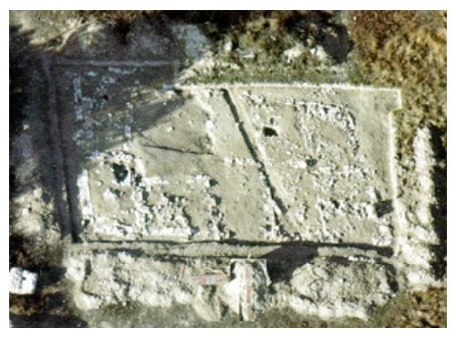
In 1981, François Salviat wanted to verify the regularity of the plan of the high city. His collaborator, Martine Willaume (conservator at the direction of historic antiquities of Provence), made test-pits and then excavations with a backhoe in the highest part of the site, which is closed to the pubic. An islet with an irregular form was revealed, as well as a large quantity of glass beads and bronze debris. In 1984, a new excavation program was begun in two areas. Gaëtan Congès and Martine Willaume continued in the area just described, while Patrice Arcelin, a CNRS researcher, worked in the lower city. The objective of this latter operation is to complete data provided by past excavations of islet 8, especially concerning the function of its different rooms and its chronology.
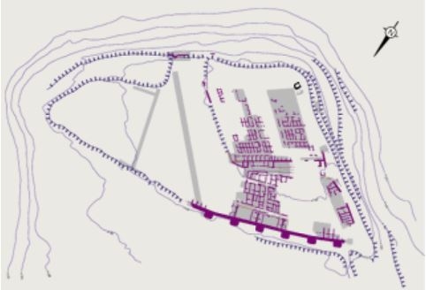
Note the irregular partitioning of islet 29. This open-air space was occupied by a domestic and artisan waste dump. Fragments of pottery, animal bones, bronze and glass beads were found there.
The goal of excavation on the summit of the plateau was to expose islet 29 in order to understand the traces of craft activities, and to verify the internal organization of this large area though the exposure of a vast horizontal surface with a backhoe. This double program operated until 1991.
In the framework of a “program” law concerning historic monuments (1988-1992), a project of restoration and adaptation was developed. From this time on, it is this project of valorization for the public that would determined the placement of excavations.
In 1992, an excavation was thus conducted by Jean-Christophe Sourisseau, an archaeologist with AFAN. It is controlled by the services of the State, in the postern sector, which will be used for the tourist circulation route.
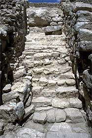
Postern