
The hinterland of Marseilles
Geographic location
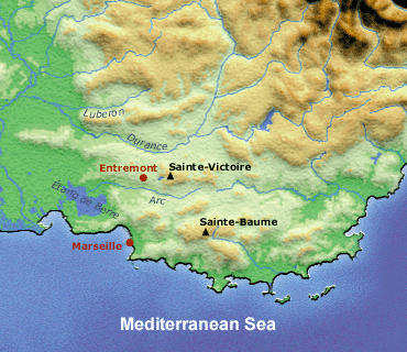
The Arc Valley, located in the hinterland of Marseilles, runs parallel to the sea and ends at Berre pond. During Antiquity, the Herculean Road, as it was called by the Greeks, followed its course. According to myth, Heracles followed this road from Iberia to Etruria after having stolen a herd of red oxen from Geryon the giant.
The site of Entremont is located on the edge of a plateau at 367 meters altitude. It dominates a nearly 200 meter wide valley below and is situated at the contact of two distinct geographic entities:
- to the west, a zone of plains and saltwater ponds separated by low hillocks;
- to the east, a zone of higher hills, or small mountains (Sainte-Victoire mountain, 1011 m altitude, and Sainte-Baume mountain,1147 m altitude), intertwined with basins and narrow valleys.
Entremont is also integrated in one of the possible routes linking Marseilles to the Alps and Italy by way of the Durance Valley, beyond which it is also possible to reach the Provence high country by crossing or going around the Luberon.