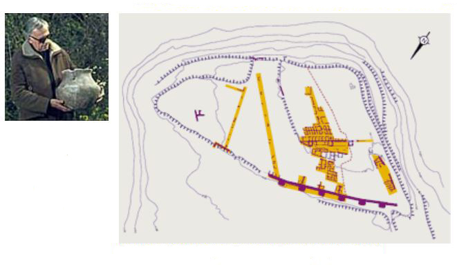
Presentation by Robert Ambard of a locally produced ceramic urn discovered during excavation conducted until 1968.
The 18th of February, 1946, Fernand Benoit and Robert Ambard opened the first of a series of trenches on the site. Their objective was twofold: to reveal the characteristics of the site, in particular its fortification, and to continue exposing its statuary. The trenches criss-crossed the entire plateau and still permit us to estimate that its whole surface (?) was occupied. The trenches were often enlarged in function of discoveries of aspects made, such as aspects of the fortification, statuary or islet walls.
DImmediately after the end of the war, the service of aerial bases and routes used the German barracks to house their emission center (Zone de Défense Aérienne 502). The plateau soon bristled with pylons and telecommunication relays, the construction of which was supervised by R. Ambard.
Until its departure for Sainte-Baume in June 1972, the presence of the air force determined the placement of excavations. These locations were authorized little by little in exchange for constructions financed by the National Education committee (1947, 1951, 1957, 1965).
Much of our knowledge of the site and its tourist circuit is a product of this German and French military presence. It is somewhat paradoxical that this site famous for it statues of warriors was in the end revealed and restricted by military actions.
Despite these complications, excavation campaigns were conducted each year with a few workers, and sometimes with the help of prisoners or students of the Ecole Normale for elementary teachers seeking an introduction to archaeology. By cutting down trees and exposing the exterior fortification, islets and streets with shovels and picks, the team led by F. Benoît shaped the plateau that is seen by visitors today. As can be expected for the time, the excavation methods favored rapidity over precision. But numerous, high-quality plans were made and the field notebooks from the first years are filled with drawings showing extraordinary life and talent. All during the excavations, the masonry structures were reinforced, restored and reconstructed under the direction of Robert Ambard.
This work conducted during the 1950’s and 60’s permitted Fernand Benoit to reveal the principal characteristics of the site: double wall, two settlements distinct in form and function, rutted road, hypostyle hall, ovens, oil presses, ceramics, jewelry, pottery, and traces of war… He presented his interpretation of the Salyen capital in a global publication in 1968.
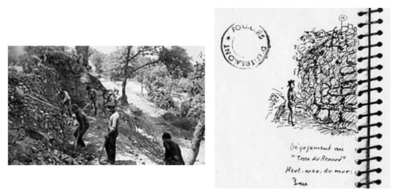
Exposure of the exterior fortification by workers in the 1950’s. Exposure at the trou de Renard, maximum height of the wall: 3 meters, October 12, 1946. Entremont field notebook, 1946 (cont.) to 1959, volume 2. Archives of the Service régional de l'archéologie Provence-Alpes-Côte d'Azur