The villa of Roye (Somme)
as revealed by aerial photography
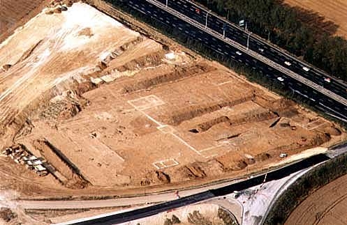
Photo taken on the excavation. Roye (Somme).
Evolution of a rural settlement
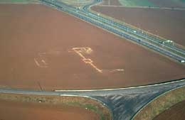
Two villas were found to the west of the town, between the TGV railway line and the A1 motorway, by the ancient road leading from Amiens to Soissons via Noyon, and close to the line between the cities of the Ambiens and the Viromanduens.
The first and larger villa was discovered by aerial photography (Agache 1970, pl. 151, fig. 482) and was excavated over two hectares by Jean-Luc Collart. There are in existence virtually complete plans of agricultural settlements which developed over nearly five centuries at the same place, in a series of successive enclosures, dating from the end of the Gallic to the Gallo-Roman period at the end of the 4th century AD(Collart, 1996, pp. 172-137, fig. 4 à 6). Only the eastern part was destroyed by the A1 motorway.
The different phases identified by the excavator may be summarised as follows:
Two late Gallic farms are represented by systems of ditched enclosures. A small curvilinear enclosure of about 1000 m² (phase 1) is inscribed within a sub-rectangular enclosure which may cover about 3800 m².
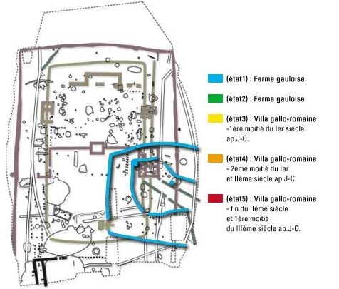

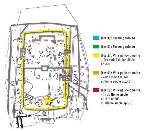


State 1 : Gallic Farm.
State 2 : Gallic Farm.
State 3 : Gallo-roman villa, 1st half of 1st century AD.
State 4 : Gallo-roman villa, 2nd half of 1st century and 2nd century AD.
State 5 : Gallo-roman villa, end of 2nd century and 1st half of 3rd century AD.
In the subsequent phase, the space is completely reorganised. A large “oval” enclosure 150 m long by 100 m wide contains a sub-rectangular enclosure of 5600 m² (phase 2). Two entrances in the shape of "micrometer calipers" allowed access to the property. These ditch layouts are very characteristic of the numerous “indigenous farms” seen from the air.
These farms can be compared to the farms of the Pays de Caux, in which the yard is surrounded by a quadrangular ditch surmounted on the inside by an embankment planted with trees. The central enclosure of the preceding farm was enlarged to the east in the first half of the 1st century AD (phase 3). An entrance is marked on the north side by two diagonal ditches.
Gallo-Roman villas are characterised by foundations of buildings, ditches delimiting the enclosures, cellars, silos, fences, pits and postholes. There are few traces of occupation before the middle of the 1st century AD. Buildings with stone foundations are difficult to date, but they would not be earlier than the middle of the 2nd century AD. Among the five structures that have been found, it is possible to identify the residential building, a small balneary, and a building with a cellar (phase 4).
At the transition of the 2nd to the 3rd centuries, a boundary wall is built, separating the first three buildings of the pars urbana from the rest of the pars rustica of the farm (phase 5).
In the first half of the 3rd century AD, the residential building is more strongly rebuilt, together with the boundary wall with its small entrance and the enclosure ditch.
The subsequent phases of occupation are more difficult to date owing to the leveling of the structures. The entire site is abandoned around 410 AD.