
From the beginning of its long history, cartography has always been considered a tool for controlling territories.
The emergence of a new discipline
For a long time the reserve of princes and their armies, this geographical discipline gradually opened up to other groups in society and more diverse areas of activity. Today its use is entirely generalised and all the richer for its direct links with numerous other sciences, making it a discipline in its own right.
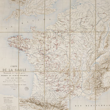
When Napoleon III founded modern archaeology in France in the 19th century, cartography was the natural choice for presenting the results of his work. Even the name of the institution responsible for this work, the Commission de la Topographie des Gaules, confirms the importance of cartography in the eyes of the emperor, who believed in the importance of taking an interest in a science in the throes of development.
How is cartography useful for archaeology?
Today, more than ever, cartography is an essential tool in archaeology. It allows archaeologists to present the information they have gathered and bring to life realities from the past in all their depth and complexity. By its very clarity, allowing the reader to take in a lot of information in just one look, the map is unrivalled in its ability to show the organisation, overlapping and interdependence of the different elements it shows.
Representing what exists however is not the end in itself, as interesting as it may be. As the centre of an information system that extends well beyond its capacity for data collection, a map is also an unparalleled projection and development tool, as seen today in its use for research as much as management. By sorting, segmenting, analysing then qualifying the data, cartography allows data to be exploited, revealing new realities, which in turn lead to further development.