Turkana, a cradle of humanity
The emergence of our species in Africa more than 230,000 years ago is just one of the many stages in the long and complex evolutionary processes that gave rise to numerous species of hominins. The south-western part of the Turkana Basin, owing to its location within the East African Rift, contains a wealth of archaeological and palaeontological evidence illustrating these stages of evolution.

The Trans-Evol project is an international collaboration involving 22 researchers from nine international institutions. It documents a key period in our evolutionary history: the transition between the Lower and Middle Pleistocene, between 1,250,000 and 750,000 years ago. Characterised by major climatic upheavals that affected all ecosystems, including the human populations of the time, this period has so far yielded only three well-preserved human fossils. The archaeological work being carried out in the south-west of the Turkana Basin should enable us to deepen our understanding of these distant cousins of Homo sapiens.
The south-west of the Turkana Basin
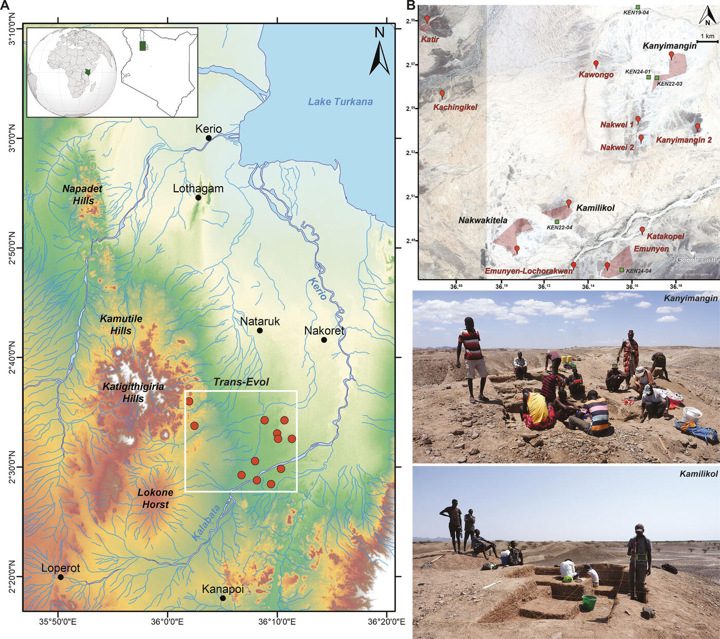
Trans-Evol operates in the south-west of the Turkana Basin. This region, which has been little explored from an archaeological perspective, is surrounded by several iconic archaeological sites. 40 kilometres to the north lies Lothagam, a site known for its human settlements dating back to the early Holocene, including the famous megalithic site of Lothagam North. About thirty kilometres to the south-west lie the Pliocene geological formations of Kanapoi, where the oldest Australopithecus fossils have been unearthed. Finally, 15 kilometres to the north lies the Nataruk site, where mutilated human remains serve as evidence of the oldest known inter-group conflicts in human history. Since 2017, Trans-Evol has been mapping the archaeological sites in this area of approximately 150 km² and has identified more than a dozen Pleistocene sites, the study of which will enable us to improve our understanding of the behavioural, cognitive and biological evolution of the human populations that lived during this period. Of these sites, Kanyimangin and Kamilikol have attracted a great deal of attention and are briefly described in this fact sheet.
Geology and chronology
The study of the stratigraphy of this region is complicated by extensive erosion and by the basin’s past seismic activity. This situation makes it difficult to establish a reliable chronology not only for the sites, but also for the area as a whole. To date, Trans-Evol has relied on magnetostratigraphy (C. Chapon-Sao, CNRS) and biochronology (M. Bosch, OEAW&; J. Marín, UNED) to date the sites. Magnetostratigraphy studies records of the Earth’s past magnetic field. The magnetic minerals contained in igneous and sedimentary rocks are capable of preserving the intensity and directions of the magnetic field at a given point in time. The Earth’s magnetic field is currently pointing towards the geographical north of our planet; this is what we call a normal-polarity magnetosphere. However, this direction does not remain stable over the course of geological time, and on numerous occasions the azimuth of the Earth’s magnetic field has pointed towards the Earth’s geographic south, i.e. a magnetosphere with reversed polarity. For example, at Kanyimangin, the upper stratigraphic layers exhibit a magnetozone of reverse polarity, whilst the lower (and therefore older) layers exhibit a magnetozone of normal polarity. The last time such a polarity reversal occurred was 990,000 years ago. These findings, combined with the presence of extinct species dating back around one million years (such as the pig Phacochoerus sp.), therefore support an age of approximately one million years for the site. The recent identification of five ash deposits from ancient volcanic eruptions — which had never been documented before — in the area where the project is operating should make it possible to estimate the chronology of Kanyimangin and Kamilikol much more accurately, as well as that of the entire Turkana Basin region. Analysing these ash deposits can indeed provide an absolute chronology or allow the volcanic eruptions that caused these accumulations to be identified.

Kanyimangin
Identified in 2010 by Robert Moru (National Museums of Kenya, NMK), the first archaeological work was carried out there in August 2017 during a survey led by Marta Mirazón Lahr (University of Cambridge), Justus Erus Edung (NMK), James Lokoruka (Turkana Bains Institute, TBI) and Aurélien Mounier (CNRS). Since then, two short excavation campaigns (2018 and 2019) and four full-scale campaigns (2021–2024) have been carried out under the direction of Aurélien Mounier. Kanyimangin is one of the few sites in Africa to have been dated to the transition from the Lower Pleistocene to the Middle Pleistocene. The 503 stone tools found there, both on the surface and during excavations, can be attributed to the Acheulean and the Middle Stone Age (analyses carried out by S. Sánchez-Dehesa Galán, University of Salamanca). The Acheulean is a stone tool industry characterised in particular by two specific types of tools: bifaces (large tools worked on both sides, see XY.14361 and XY.14412) and choppers (retouched flake tools, see XY.14590 from Kamilikol). It first appeared in Africa 1.75 million years ago, where it was gradually replaced by the Middle Stone Age between 500,000 and 200,000 years ago. Consequently, the assemblage identified at Kanyimangin provides evidence of a long period of occupation of the area and offers significant potential for exploring the technical and cognitive evolution of early hominins through their stone tools. The site has also yielded a significant collection of faunal remains of more than 238 individuals (2,271 fossil fragments analysed by M. Bosch, OEAW, and J. Marín, UNED). In the years to come, this collection will help to clarify the taxonomic and systematic classification of several fossil taxa, particularly with regard to the families Suidae (see XY.14368) and Elephantidae (KNM-WT 95693), whose classifications are continually being revised.

Kamilikol
Kamilikol is situated about ten kilometres south of Kanyimangin, and was identified by Aurélien Mounier (CNRS) and Justus Erus Edung (NMK) in June 2022. The site has yielded a significant lithic assemblage, derived both from survey work (surface) and from the excavation of an area of 13 m², of which the 571 artefacts form a coherent assemblage belonging to the Acheulean techno-complex (analysis by S. Sánchez-Dehesa Galán, University of Salamanca). This classification is based, in particular, on the very abundant presence of bifaces, one of the most characteristic artefacts of the Acheulean period. Although this type of tool first appeared in the northern part of the Turkana Basin 1.75 million years ago, it is subsequently very rarely found in the stone tool assemblages described in this region. At Kamilikol, 70 bifaces have been identified to date (see XY.14588, 14591, XY.18230 and XY.18232), making Kamilikol an exceptional site with no equivalent in Western Turkana. Faunal remains, on the other hand, are very rare at Kamilikol, and only 91 faunal fragments have been identified.

Future missions
Archaeological work will continue in this region over the coming years, with the aim of refining the chronology of the identified sites and continuing their study in order to enhance our understanding of the cultural and biological evolution of hominin populations during the transition from the Lower Pleistocene to the Middle Pleistocene, as well as to continue the precise archaeological, palaeontological and geological mapping of this region of the Turkana Basin.
Project supported by the Ministry for Europe and Foreign Affairs on the recommendation of the Excavations Commission.