Tell Yanouh-Mghaïra
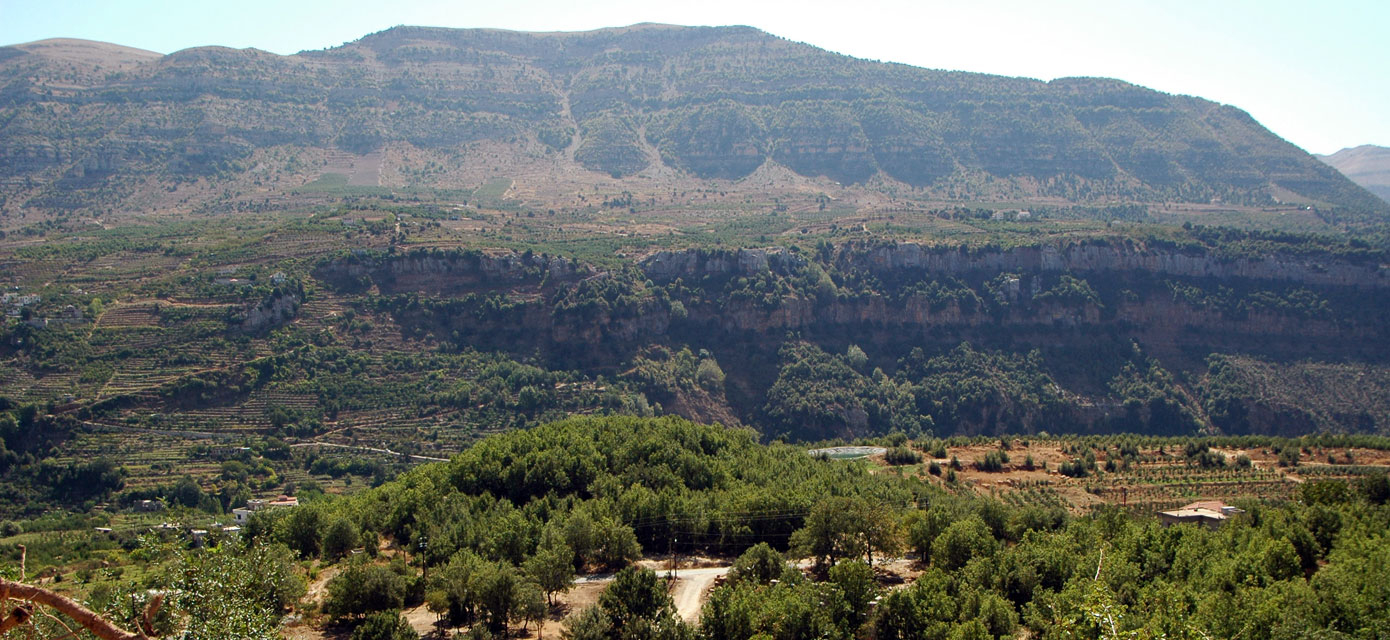
Overlooking the gorges of the upper valley of the Nahr Ibrahim, the Adonis river of Antiquity, the Tell el-Kharayeb (the ruins in Arabic) of Yanouh-Mghaira is a grouped habitat in the hinterland of Byblos (present-day Jbayl), almost unknown until 2002. Recent excavations lifted the veil on more than 5,000 years of history in the mountains of Lebanon, from at least the Early Bronze Age to the Ottoman period.
The Tell el-Kharayeb has many qualities for the archaeologist, making it a unique site to understand the development of societies and territories in the central Levant over the last three millennia BCE: its mountain location, stratified layers several metres thick, a permanent grouped habitat, and the length of its occupation.
A major site in a still little-known part of Lebanon
El-Kharayeb, a place name passed on through the oral tradition, despite not being mentioned on maps and plans, is located in the hinterland of Byblos, itself inscribed on the UNESCO World Heritage List. Although not found in the written sources, this mountain archaeological site warranted a brief mention at the end of the 19th century by Ernest Renan in his Mission de Phénicie, where he describes it as a "small mound of ruins", to the south of the Greco-Roman sanctuary of Yanouh-Mghaira.
Until the end of the 20th century, the Lebanese mountain of Antiquity was thought of as a wilderness, inhabited and haunted only by bandits and woodcutters who came to cut the celebrated cedars of Lebanon to construct buildings (temples and Egyptian and Mesopotamian palaces) and build the boats that charted the Eastern Mediterranean.
A multi-disciplinary group discovered the scientific importance of Yanouh-Mghaira for archaeological research, which brought about a radical shift in our understanding of the site by demonstrating how the reliefs above 1,000 metres had been occupied over long periods and the land terraced for farming for at least 5,000 years. The relief, climate, soil quality and presence of permanent springs were all factors in where the tell was located, revealing how the agglomerated habitat became settled at an early stage, along with the construction of agricultural landscapes, about which much less is known than the celebrated urbanism of contemporaneous cities on the coastal plain.
A mountain habitat in the early 3rd millennium
Since 2014, archaeologists have studied the oldest known ancient habitat in the Lebanese mountains to date - a large village with an estimated maximum surface area of 6 hectares, dated to the early 3rd millennium BCE. Outstanding findings were discovered for this period about which little has been recorded in Lebanon until now. The Tell el-Kharayeb was settled by a sedentary and organised population. It practiced terraced farming, reared cattle and made farming equipment, and local potters produced a standardised form of pottery crockery. The discovery of a large room with four rows of pillars, measuring 34 m2, where foodstuffs were stored for redistribution and trade, inside a building with multiple rooms, sheds fresh light on the mountain habitats of Lebanon during this period in the Near East. Another contemporaneous site, Tadmor, unfortunately heavily destroyed in recent years, stands on a rocky spur overlooking the aveolate feature on which the tell is located.

The territory in which the tell is located was neither on the fringes nor isolated. It was perfectly integrated into a trading network with neighbouring and more distant regions, including with the South Levant and Egypt. The site is comparable to Early Bronze Age sites on the Syrian-Lebanese coast, in terms of its architecture and the methods used to produce food and craftwork; while some architectural features are specific to the site, such as techniques that closely combine conifer wood and unfired earth to produce wooden panels, adobe and cob.
The long history of terrace-farmed land

With a view to better understand the mountain settlement, since 2001 archaeological research has also focused on the landscape around the habitat and its necropolis. The excavations performed in the terraced fields revealed several cultivation phases: the early 3rd millennium BCE (Early Bronze Age), the 1st millennium BCE (Iron Age) and the first half of the 1st millennium (Roman/Protobyzantine) and at least two phases when the plots were redeveloped during the Medieval period, the oldest dating from the Abbasid/Crusader period (11th-13th century) and the most recent being the late Medieval period (Mamluk).
The many carbonised seeds and pits found in the habitat attest to the wealth of finds discovered on the archaeological site. Barley, wheat, legumes, vines and olives were grown there from the early 3rd millennium BCE and some cereal fields were irrigated.
A well-visited sanctuary in Antiquity
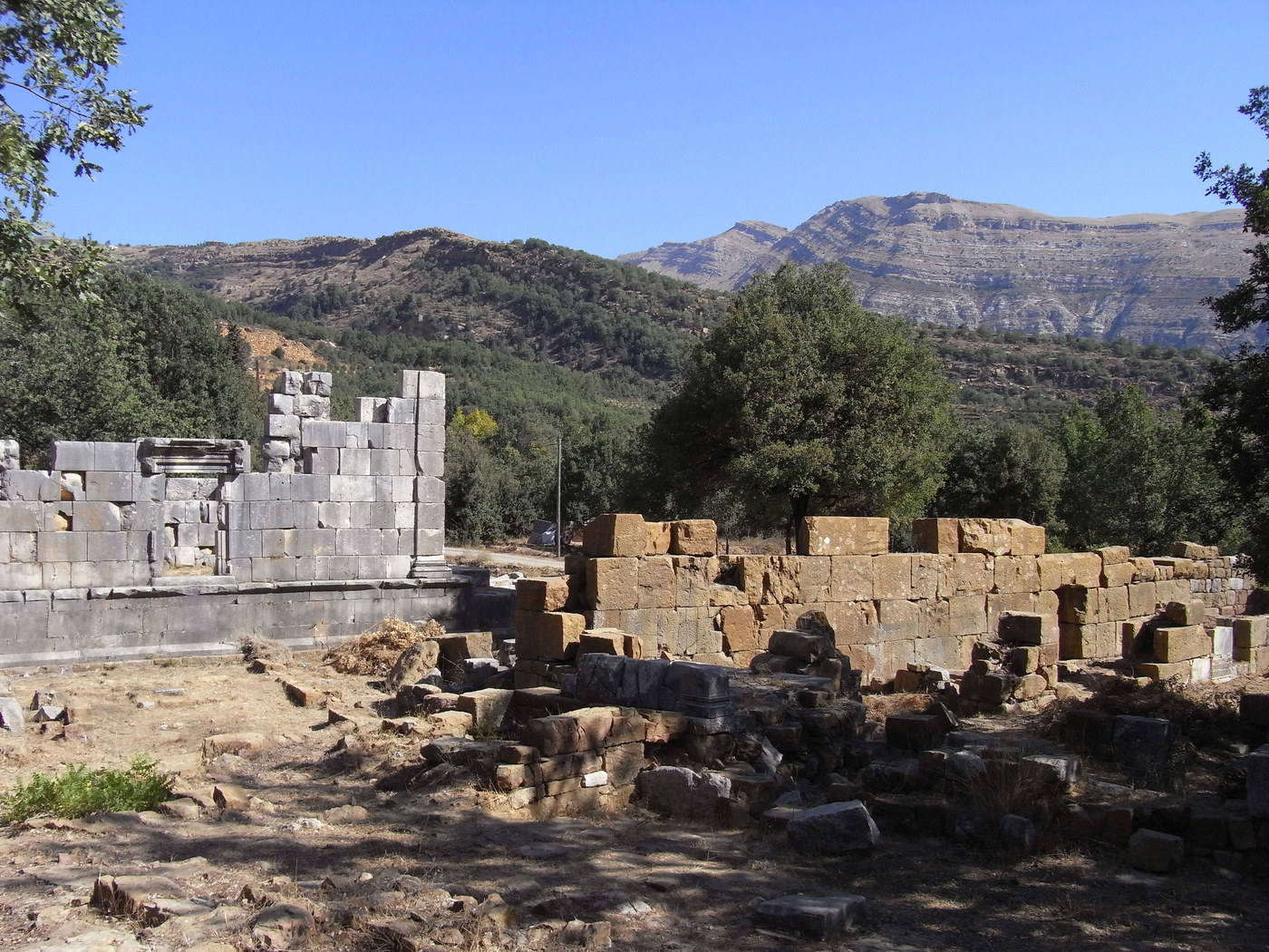
The Yanouh-Mghaira site is known for its Greco-Roman sanctuary on an ancient route that follows the valley of the Adonis river to its source. It contains the sanctuary of Afqa, a renowned pilgrimage centre in Antiquity, to where pilgrims travelled from the city of Byblos. The oldest Aramean inscription in Lebanon, now lost, was found in the 1960s at the site of the sanctuary of Yanouh-Mghaira. It mentions the construction of a temple. The remains of the great temple and its peribolus are still visible, as are those of a basilica with three naves dated to the end of the 5thcentury. It is one of the oldest Christian religious monuments in the Lebanese mountains.
A society open to the Mediterranean world
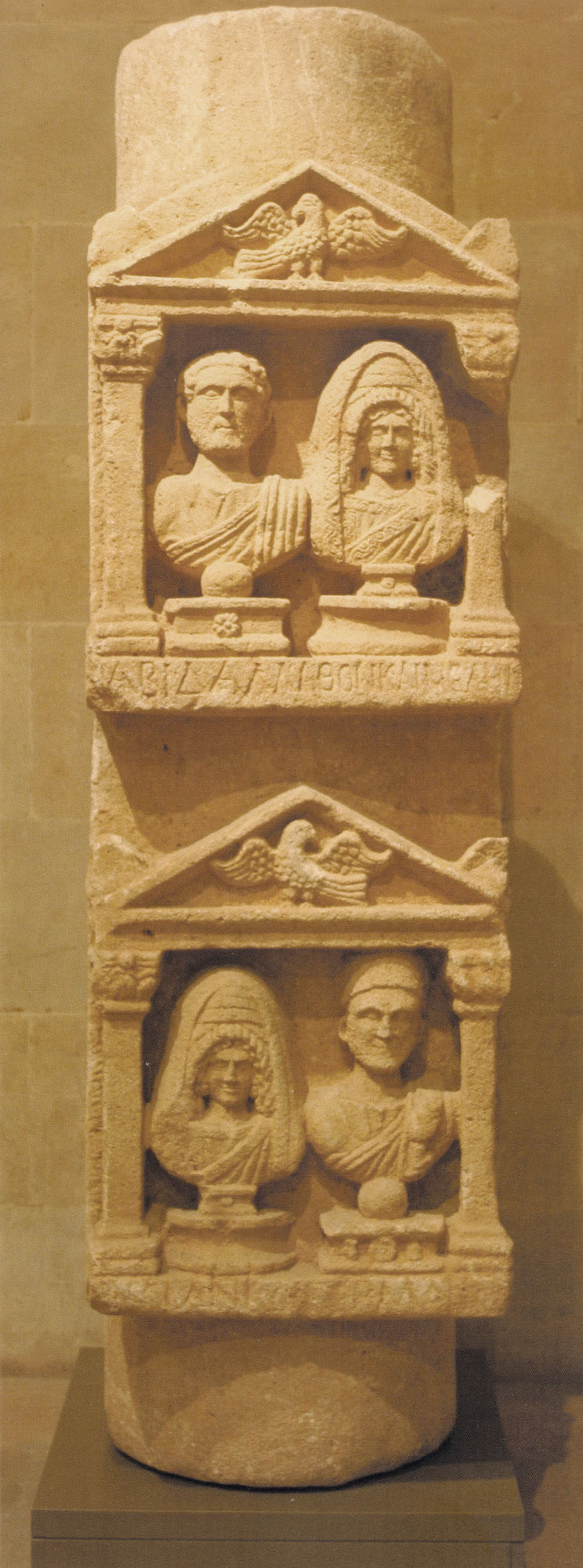
The habitat dating from the Roman and Byzantine period is adjacent to the sanctuary. However, the site was occupied, almost unbroken, from the 3rd millennium BCE. In the Greco-Roman period, the population of the mountain was identified as Itureans whose portraits appear to feature on a funerary column dated to around 120-160 CE. It was discovered in the 1940s in the neighbouring village of Qartaba and is conserved in the National Museum of Beirut, but is contemporary with the sanctuary of Yanouh-Mghaira. Two couples, one a priest, are depicted in the portrait that combines Greco-Roman and Oriental styles of dress. The four names inscribed in Greek are of Latin and Semitic influence, one of which looks to be Iturean in origin.
A village, its cemetery and its places of worship in the Middle Ages
In the early Middle Ages, Yanouh was the seat of the Patriarch of the Maronite Christians. Two papal bulls issued by Innocent III and then Alexander IV attest to his presence in the 13th century. These manuscripts are conserved in the archives of the patriarchal palace of Bkerki in Lebanon. The archaeological excavations carried out since 2014 on Tell el-Kharayeb revealed a Medieval necropolis, associated with several chapels, where the dead were buried from the 11thcentury and until the 14thcentury, on the southern edge of the densely built village.
A multi-disciplinary team
The Mission archéologique Nahr Ibrahim has been excavating the Tell of Yanouh-Mghaira since 2014, under the direction of Romana Harfouche (ArScAn, Paris-Nanterre) with support from the General Directorate of Antiquities of Lebanon. It is supported by the French Ministry for Europe and Foreign Affairs, on the advice of the Advisory panel on archaeological research abroad (CCRA), the Institut Français du Proche-Orient (IFPO) and the CNRS (UMR 4071-ArScAn, APOHR team). It also benefits from private Lebanese sponsorship, including the landowner who granted access to the archaeological excavations free of charge, by halting the permanent destruction of the site by terracing for apple trees.
The study combines archaeological and historical research with environmental sciences - primarily geosciences. It was partly initiated in 2001 and implemented more recently within the framework of a French-Lebanese project, CEDRE (dir. R. Harfouche for the French team).
The researchers, lecturers and engineers (14 people in total) involved in the project report to the French CNRS, Université de Paris Panthéon-Sorbonne, Université Libanaise (UL), and the General Directorate of Antiquities of Lebanon (DGA), the Lebanese International University (LIU) and the Satellite remote sensing centre (CTS) of the Lebanese CNRS. Most members are archaeologists, associated with other subject-specific competencies: written sources, ceramic and lithic material analyses, pedology, geomorphology, archaeozoology, phytolith analysis, carpology, anthracology, geomatics and radio-chronological dating.
Learn more: Visit the blog of ArchéOrient