Ancient Vienne
In ancient times, Vienne stretched along both sides of the Rhône. A simple Gallic settlement, under the Roman Empire the town became the administrative centre of the vast Allobroges territory. Numerous ancient authors praised the power and beauty of the city, which could easily compete with other cities in the Narbonne region for the title of "Little Rome of the Gauls".
An eventful history
Vienne's privileged location at the crossroads of routes along the river and over land was undoubtedly one of the key factors in its development in Roman times, making it one of the richest cities in Gaul. The metamorphosis of the Rhône, which changed from a braided river to a meandering one in the 1st century B.C. —– thus freeing up many flooded areas —– also facilitated the development of the settlements along its banks.
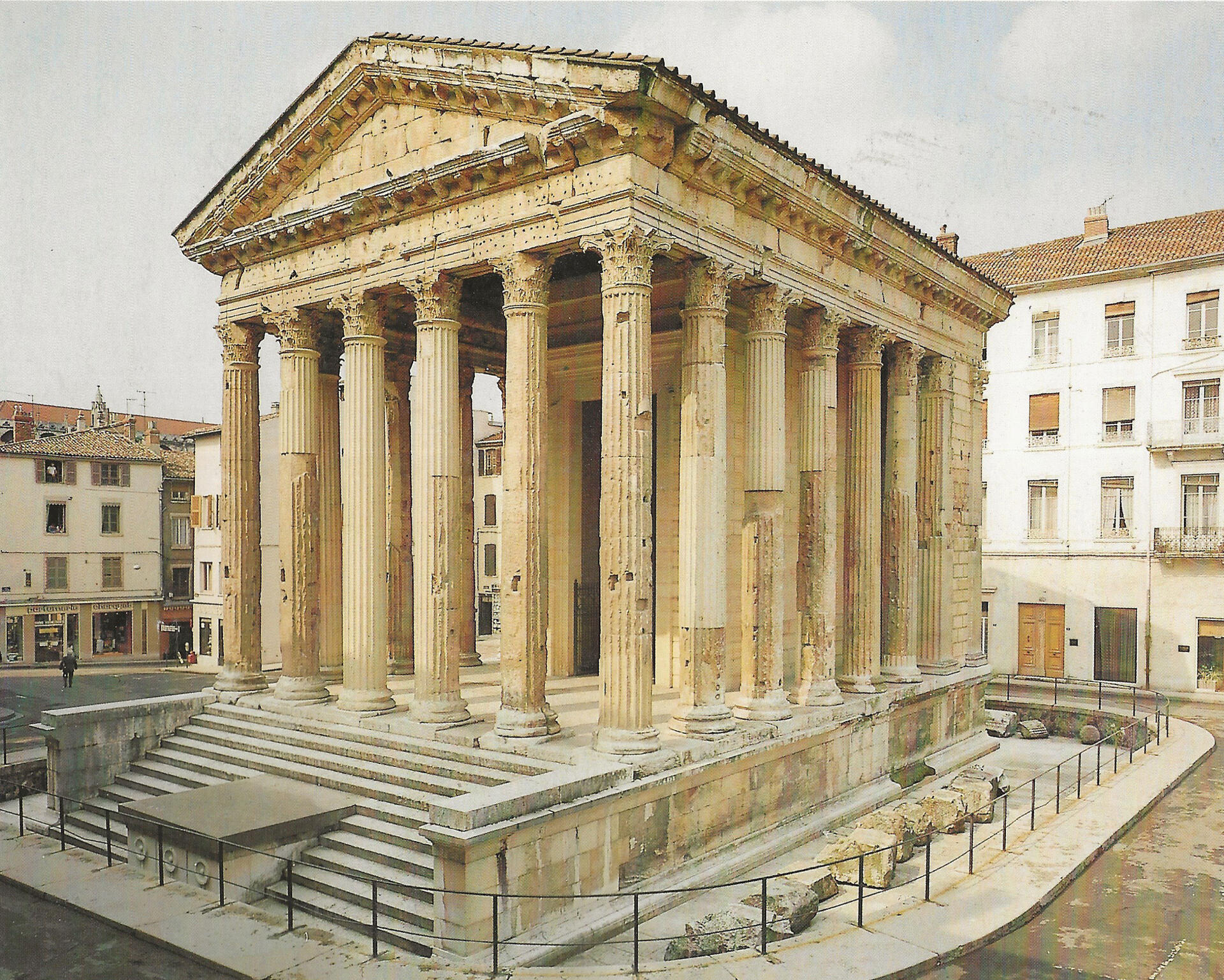
This rapid urban growth was particularly marked during the reign of Claudius (r. 41 to 54 AD), as evidenced by several phenomena. Firstly, numerous inscriptions mentioning major acts of euergetism have been found, revealing the involvement of the elite in the city's development. In addition, archaeological evidence of chronologically synchronous destruction and reconstruction is gradually fueling the hypothesis that an earthquake struck the city during the reign of the emperor Caligula (r. 37 to 41 AD), probably in 36 or 37 AD. Parts of the famous Temple of Augustus and Livia therefore date back to two different periods, one being that of its initial construction under Augustus and the other the renovation of its eastern façade under Claudius. This would have enabled the city to continue its development, with the added benefit of imperial aid.
This hypothesis was artistically evoked by Gilbert Bouchard when he published an album entitled Les voyages d'Alix – Vienne (see drawing below).

Vienna pulchra, "Vienne the beautiful"
The city's wealth and beauty were praised by ancient authors such as the emperor Claudius, who described it as follows: Ornatissima ecce colonia ualentissimaque Viennensium, "The highly honourable and powerful colony of the Viennese" (Tables claudiennes) and the poet Martial praises its beauty: Vienna pulchra, "Vienne the beautiful" (Epigrams, VII, 88). Recounting the conflict between two pretenders to the throne, Vitellius and Galba, in 68/69 AD, the historian Tacitus mentions "the gold of the Viennese", which was coveted by the Lyonnais, supporters of Vitellius (Tacitus, Histories, I, 64-66). The ransom paid by the defeated Viennese is estimated at 12 million sesterces. This episode testifies to the wealth of the city, which can be seen in the exceptional and ostentatious adornment of its monuments, but also in the luxury of the houses of public figures.
Of the eight monumental temples on record, only the Temple of Augustus and Livia has survived, virtually intact, along with the arches marking the entrance to the forum.
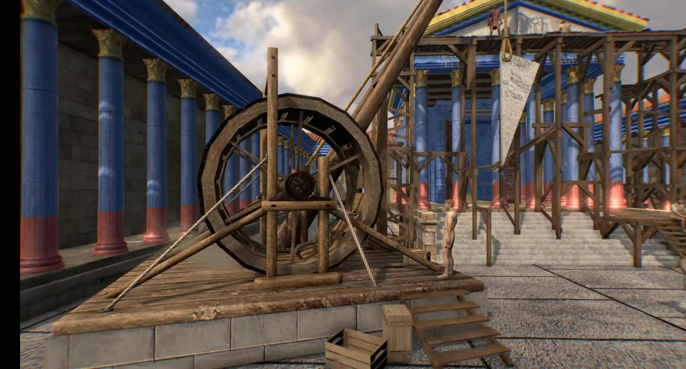
The video below is a proposed three-dimensional reconstruction of the technical means used to install the tympanum of the Temple of Augustus and Livia, between 27 BC and 14 AD.
Water monuments (aqueducts, fountains, thermal baths), inseparable from the Roman art of living, were undoubtedly more numerous than in other cities of similar importance.
Structures built for entertainment (theatre, circus, odeon, amphitheatre) contributed to the city's monumental appearance.
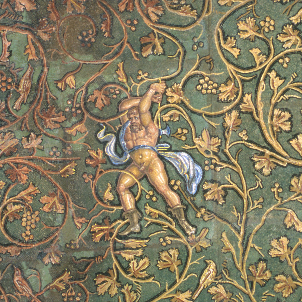
The city’s domus, Italic in their design and sometimes gigantic in scale, boast an exceptional décor. Vienne is a therefore a site of major importance for Roman mosaics; more than 580 pavements have been counted, and there is undoubtedly potential for just as many more. The mosaics, with their mythological themes, and the statues of gods and goddesses adorning the gardens demonstrate that Vienne was a city of great culture.
The decline
But this opulence, brought about by the flourishing of crafts and industry, was undoubtedly the cause of the city's decline, which began to take hold at the end of the 2nd century AD, a decline that can be seen in the abandonment of the southern districts on the left bank and those on the right bank. This reduction in the built-up area went hand in hand with a sharp decline in the population. In the space of a century, Vienne's population is estimated to have fallen from almost 25,000 to 5,000. This "crisis of the 3rd century", which for many years was attributed to a political crisis coupled with an economic crisis and invasions, is undoubtedly mainly due to a health crisis.
In Vienne, the lead industry (extraction and processing of ore, manufacture of artefacts from imported lead) probably poisoned the population, who drank more water that had passed through lead pipes. Analyses of several skeletons from this period have revealed fatal levels of lead poisoning.
In addition, the over-consumption of wood, particularly in the city's many thermal baths, combined with uncontrolled deforestation around the city, probably caused a phenomenon that is well known today, the creation of fine carbon particles. It is likely that the people of Vienne also suffered from this air pollution, which can cause many forms of cancer.
Vienne's heyday lasted just two centuries, but the city regained some of its splendour at the dawn of Christianity, in the 4th and 5th centuries AD.

Archaeological research in Vienne
The ancient site of Vienne is currently the subject of a Collective Research Project (Projet Collectif de Recherche [PCR]) entitled "VIENNE, SAINT-ROMAIN-EN-GAL, SAINTE-COLOMBE – Atlas topographique de Vienne antique” (VIENNE, SAINT-ROMAIN-EN-GAL, SAINTE-COLOMBE – Topographical Atlas of Ancient Vienne).
Under the direction of Aurélie Monteil (Regional Archaeology Department), this PCR is a continuation of the initial Topographical Atlas of Ancient Vienne programme, which dates back to 1982. This collective undertaking was supported by the state and local authorities, with the aim of studying and showcasing the archaeological heritage of Vienne that has been preserved on both banks of the Rhône. This programme adopted the methods and principles of the Topographical Atlases of the Towns of Southern Gaul, a project that was launched in the early 1990s. It ended in 2012.
The aim of this new PCR is to generate new momentum in this area of research with a view to eventually publishing all the ancient topographical data for the two banks. It brings together all the researchers involved on both sides of the Rhône.
Useful links
- Vienne Town Hall
- Heritage-related activities
- Vienne/Condrieu Tourist Office
- Vienne, City of Art and History
- Future Vienne History Museum
- Saint-Romain-en-Gal Museum
- Via Rhona
- A virtual tour of Gallo-Roman Vienne
- A virtual tour of Gallo-Roman Vienne: version produced with secondary school pupils (Arrête ton char !)